
|
|
Use these navigation links to move between the Year 2023 pages. Specific pages can be accessed at the bottom of this page
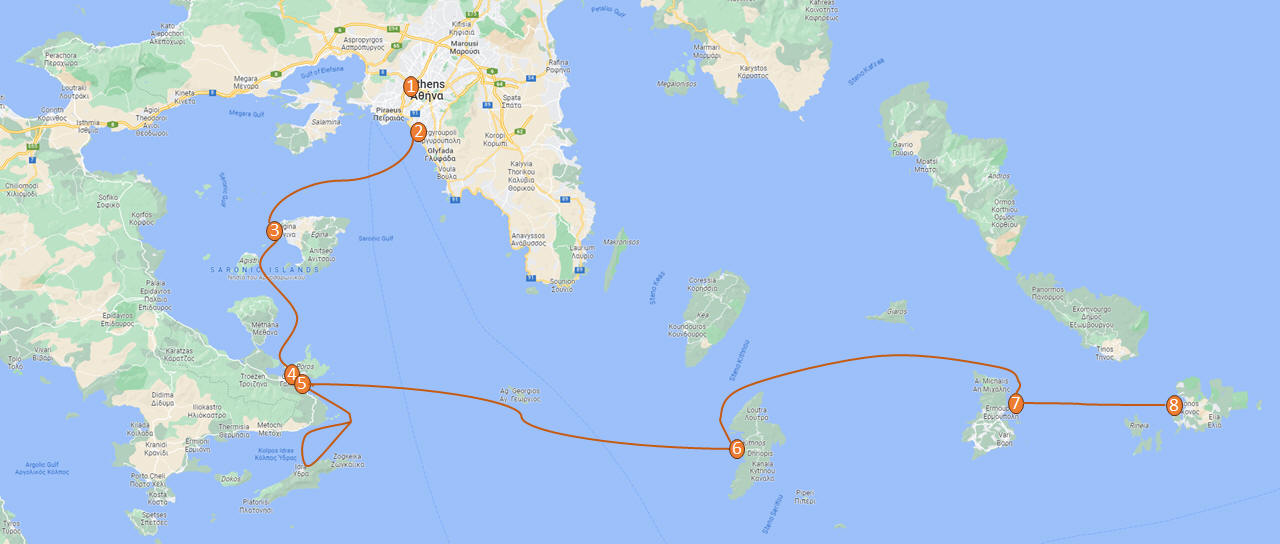
May 2023 (Part 13) Greece/Spain Trip - Day 6, May 18 - Kythnos This day was our long crossing from Poros to Kythnos, which Captain Marek said would take between 7 and 9 hours. We left pretty early, around 6:30. We got up to help again while the rest of the crew stayed in bed. That turned out to be a bit of a mistake for them, as the wind and the seas were up a bit, although mostly coming from behind earlier in the morning. No one who needed it got up to take Dramamine before departure and several people were feeling ill by the time they made it on deck. Fortunately most felt better in a while once on deck.
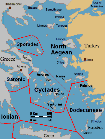
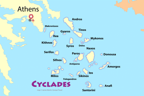
The crossing took us across part of the Aegean Sea to the Cyclades Islands. The name Cyclades "(Κυκλάδες νήσοι, Kykládes nísoi, 'encircling islands') refers to the archipelago forming a circle (or cycle) around the sacred island of Delos (close to Myconos). The largest island of the Cyclades is Naxos, however the most populated is Syros. The islands have been inhabited since before the Late Neolithic and Early Bronze Age, with evidence of early copper workings. A distinctive Neolithic culture amalgamating Anatolian and mainland Greek elements arose in the western Aegean before 4000 BCE. Each of the small Cycladic islands could support no more than a few thousand people, though Late Cycladic boat models show that fifty oarsmen could be assembled from the scattered communities, and when the highly organized palace-culture of Crete arose, the islands faded into insignificance, with the exception of Delos (revered as the birthplace of Apollo and Artemis, acted as the center and meeting place of the early Athenian League, and is one of the most important mythological, historical, and archaeological sites in Greece), which retained its archaic reputation as a sanctuary throughout antiquity and until the emergence of Christianity. The Cyclades includes about 220 islands. Ermoupoli on Syros is the chief town and administrative center of the former prefecture. The islands are peaks of a submerged mountainous terrain, with the exception of two volcanic islands, Milos and Santorini. The climate is generally dry and mild, but with the exception of Naxos, the soil is not very fertile; agricultural produce includes wine, fruit, wheat, olive oil, and tobacco.
About halfway across we passed close by the uninhabited island of Agios Georgios (St George), which is essentially a barren rock with a large number of windmills for power. The 23 windmills provide power to the mainland via an undersea cable.
The wind died down in early afternoon and we were forced to motor the rest of the way. Unfortunately, the seas were still a bit high. Several people took turns at the helm, mostly to help distract them and get them to focus on the horizon, and help calm their stomachs. Andy took this as an opportunity to present Steve with a Captain's hat as a funny way of thanking him for getting up early to help.
Kythnos was pretty small, even smaller than Hydra Port.
Captain Marek had arranged a group tour of Dryopida Village with local tour guide George. According to Marek's message, "Dryopida is the most traditional village on the most traditional island of the Cyclades." Beautiful white and blue houses on narrow streets. There is also a very big cave in the middle of the village. It is named as a traditional settlement because of its architecture. The village only has an estimated 325 inhabitants. The main characteristic of this community are the tiled ceramic roofs, which can be mainly traced back to the occupation of its inhabitants, tilers and roofers in Athens, who brought back the custom of roofing to their place of birth. It's name Dryopida, is the ancient name of Kythnos, named after Dryopes (an aboriginal tribe of ancient Greece) considered the first inhabitants of the island. George explained that Dryopida is the main city on the island. Unlike most islands, it is up in the hills instead of along the shore. There is a small valley, which ensured the ability to collect water. It is about a two-hour walk from the shore, and because it's in a valley, it isn't really visible from the shore. This made it much harder for pirates to find. This was another reference to pirates in the area, and George explained that it was a real problem for hundreds of years with the intersection of Roman, Greek, Turk and other trading routes through the area. George also explained that the island was terraced originally to grow barley and hops, while all of the stone walls were created when the island was ruled by Venice, who introduced feudalism, which required the ability to designate property. There were many paths designated by dual walls which allowed people to travel without crossing the private lands. These paths were dotted with small chapels, allowing people to stop and pray on trips. In the end, George stated there was a church for about every 4-5 people on Kythnos. The windmills doting the landscape were built to help mill the grain and then make it easier to transport.
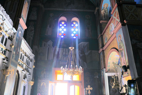
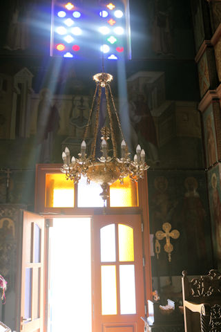
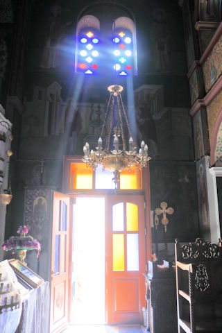
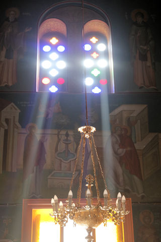
One of our first stops was at the Holy Church of the Holy Apostles, which is the central church of the Dryopida settlement rising between the beautiful traditional houses. We notes the beautiful wood carvings, again featuring images of a double-eagle. Steve asked George about this recurring image. George, quick with the answer, explained it was a traditional symbol of the Roman Empire, which was continued in Byzantine images and heraldry, representing the dual sovereignty of the emperor both in secular and religious matters and/or dominance over both East and West. It was used in the Byzantine Empire's flag until its dying days in 1453, then it was adopted for use by the Greek Orthodox Church in its flag and key motifs as a way of continuing the Roman or Catholic Church in the east which became the Greek Orthodox with the split of popes along with emperors between Rome and Constantinople.
There were several wonderful painted icons.
The narrow white washed streets were amazingly beautiful. We asked George about the white and blue color scheme. He explained that white was the cheapest and helped keep the sun's heat out, so was common. Traditionally, the accents were done with left-over boat paint, with shades of blue, but also green, red/ochre, and yellow. Blue was indeed the most common accent color for doors and shutters in the Cycladic islands because it was usually the cheapest and most readily available paint color available. The blue used for Greek island homes was made from a mixture of limestone and a cleaning product called “loulaki,” which was a kind of blue talcum powder most islanders had readily available at home. The limestone used in the white paint helped as an antiseptic. Then in 1938, a national order mandated the painting of island homes in blue and white. At the time, Greece was suffering an outbreak of cholera during the dictatorship of Ioannis Metaxas. In an effort to curb the disease, he ordered citizens to whitewash their homes. Finally, the military dictatorship which took over Greece in 1967 believed the colors would inspire patriotism and were reflective of Greek nationalism. Eventually, they passed a law in 1974 to mandate the painting of Greek island homes in blue and white. Although these regulations have now been relaxed, the blue and white colors of the Greek islands have become a huge draw for travelers. George explained that there are now more colors again, although really only as accent colors, as the different colors cost more and are a way for a family to advertise their wealth and prosperity to the neighbors.
We then came to the Katafyki Cave at a high point above the village. Trough the ages, the cave has served as a refuge, food storage area (as its temperature always hovers around 17°C), a place of celebration, and a mine. It also bears the name "Giorgos Martinos Cave" in honor of the geologist who studied it. The main part of the cave is natural, of which more than 600 meters have been mapped and which holds many stalactites and stalagmites. The stalactites in the hall are of various colors and shapes and have names such as 'jellyfish', 'octopus', 'teddy bear', etc. A large stalagmite is called 'Tower of Babel'. To the right of the room are sheets of limestone and iron ore. In another area of the cave, there is a "trough" formation as water accumulates there between the stalactites and stalagmites. Over many generations, the cave has been greatly expanded with a 2000 meter-long man-made gallery, a mined area, and a mine shaft leading miles away to the ocean. Long tunnels have been formed in the cave due to the flow of water from a torrent. It is estimated that the cave's passageways cover an area of 3500 square meters in total. At the entrance there is a plateau called the 'small plateau' and further on lies the 'large plateau' or piazza. In the 'large piazza' people of Dryopida used to hold religious festivals after the Resurrection during Easter. Further to the right there are corridors, two of which lead to the 'stalactite hall', of an area of 25x17 meters, where one can find stalactites and stalagmites. The rocks of the cave are stratified vertically into shale, marble and slate. George pointed out the original entrance, which was rather small. He explained that the villagers could retreat into the cave as a sanctuary, providing a hard to find and defensible location to protect against pirate raids and attacks. Consequently, each family was allotted an area and used it to store food and other items in the cool and dry cave. The cave also provided a pace for village celebration, as all of the villagers could assemble in a couple areas. Many of the villagers were married here instead of the church, which didn't exist until much later. They have now added a new and easier to navigate entrance, while also creating better steps for a circular path and route through the cave. He also discussed the cave's use as an iron mine, dating back to antiquity, as there are references to metal mines in Kythnos in the literature. Iron mining in modern times lasted from 1835 (after the founding of the modern Greek state) to 1940, while after 1910 exploitation was carried out by foreign companies. They mined hematite as the main mineral. There were still rails leading down the shaft to the sea, operating as a funicular over the several mile distance, with one care loaded going downhill and another being pulled back up. He also showed the remains of several wagons and mining tools.
We passed one larger, private garden/orchard on the way down.
We soon arrived at Helgen Panteleimon, a small Greek Orthodox church.
As we wandered, George pointed out several plants which were recognizable herbs growing in seemingly random places around the winding streets.
Lexi made a couple friends as we walked.
We wound up back at the harbor with a bit of time to wander before making our way to the Byzantio Yalos restaurant for dinner, which had a small and wonderful covered seating area on the sand right in the harbor. We then went to another wine bar. While we headed to bed, Andy and the others stayed for a couple more drinks. Apparently George came by later and joined them on the boat for a long discussion.
Loved the real octopus hung for display, yes it was real, yes Steve felt it to check.
Here is Captain Marek.
We were able to leave a bit later the next day as the crossing would be shorter, 4 to 5 hours.
|
|
|
.PNG)
.JPG)
.JPG)
.JPG)
.JPG)
.JPG)
.JPG)
.JPG)
.JPG)
.JPG)
.JPG)
.JPG)
.JPG)
.JPG)
.JPG)
.JPG)
.JPG)
.JPG)
.JPG)
.JPG)
.JPG)
.JPG)
.JPG)
.JPG)
.JPG)
.JPG)
.JPG)
.JPG)
.JPG)
.JPG)
.JPG)
.JPG)
.JPG)
.JPG)
.JPG)
.JPG)
.JPG)
.JPG)
.JPG)
.JPG)
.JPG)
.JPG)
.JPG)
.JPG)
.JPG)
.JPG)
.JPG)
.JPG)
.JPG)
.JPG)
.JPG)
.JPG)
.JPG)
.JPG)
.JPG)
.JPG)
.JPG)
.JPG)
.JPG)
.JPG)
.JPG)
.JPG)
.JPG)
.JPG)
.JPG)
.JPG)
.JPG)
.JPG)
.JPG)
.JPG)
.JPG)
.JPG)
.JPG)
.JPG)
.JPG)
.JPG)
.JPG)
.JPG)
.JPG)
.JPG)
.JPG)
.JPG)
.JPG)
.JPG)
.JPG)
.JPG)
.JPG)
.JPG)
.JPG)
.JPG)
.JPG)
.JPG)
.JPG)
.JPG)
.JPG)
.JPG)
.JPG)
.JPG)
.JPG)
.JPG)
.JPG)
.JPG)
.JPG)
.JPG)
.JPG)
.JPG)
.JPG)
.JPG)
.JPG)
.JPG)
.JPG)
.JPG)
.JPG)
.JPG)
.JPG)
.JPG)
.JPG)
.JPG)